Datasets and Processing

Data Preprocessing

To ensure consistency and analytical value, all datasets underwent a standard preprocessing workflow involving cleaning, filtering, and harmonization. The five primary sources—S2ID, INMET, MapBiomas, IBGE, and geospatial shapefiles—were integrated at the municipality level.

The S2ID disaster records were filtered for hydrological events in 2024, cleaned for encoding issues, and aggregated into a single impact indicator.

INMET precipitation data from over 500 stations was standardized and joined with location metadata. Using MapBiomas, we calculated urban and forest cover change between 2013 and 2023, as well as exposure to urban flood risk zones. IBGE demographic data helped normalize indicators. All datasets were matched by municipality and state, producing an integrated file ready for visualization and analysis.

Datasets Source and Catalog
D1 - Disaster Records (S2ID)

  • ID: D1_Disaster_and_Impact_Data
  • Publisher: Ministry of Integration
  • Format: CSV
  • Metadata: Provided
  • URI: https://s2id.mi.gov.br/
  • License: Public Domain, Brazil Government

D2 - Rainfall Data (INMET)

  • ID: D2_Rainfall
  • Publisher: INMET
  • Format: CSV
  • Metadata: Provided
  • URI: https://bdmep.inmet.gov.br
  • License: Public Domain, Brazil Government

D3 - Population Estimates (IBGE)

D4 - Urban Expansion (MapBiomas)

  • ID: D4_Urban_Expansion
  • Publisher: MapBiomas
  • Format: XLSX
  • Metadata: Provided
  • URI: https://data.mapbiomas.org
  • License: CC BY-SA 4.0

D5 - Deforestation (MapBiomas)

D6 - Civil Defense (Transparency Portal)

MD1 - Affected Population

  • ID: MD1_Affected_Population
  • Publisher: Open Data Floods
  • Format: CSV
  • Metadata: Provided
  • URI: Affected Population
  • License: CC BY-SA 4.0

MD2 - Rainfall per Municipality

  • ID: MD2_Rainfall
  • Publisher: Open Data Floods
  • Format: CSV
  • Metadata: Provided
  • URI: Rainfall per Municipality
  • License: CC BY-SA 4.0

MD3 - Deforestation Rio Grande de Sul

D4 - Rain Precipitation per States

  • ID: MD4_Rain_Precipitation_States
  • Publisher: Open Data Floods
  • Format: CSV
  • Metadata: Provided
  • URI: Rain Precipitation per States
  • License: CC BY-SA 4.0

D5 - Monthly Rainfall Stations RS

  • ID: MD5_Monthly_Rainfall_Stations_RS
  • Publisher: Open Data Floods
  • Format: CSV
  • Metadata: Provided
  • URI: Monthly Rainfall Stations RS
  • License: CC BY-SA 4.0

MD6 - Urbanization Growth RS

  • ID: MD6_Urbanization_Growth_RS
    • Publisher: Open Data Floods
    • Format: CSV
    • Metadata: Provided
    • URI: Urbanization Growth RS
    • License: CC BY-SA 4.0

GD1 - Municipal Boundaries

  • ID: GD1_Municipalities
  • Publisher: Instituto Brasileiro de Geografia e Estatística
  • Format: SHP
  • Metadata: Provided
  • URI: https://www.ibge.gov.br/
  • License: Public Domain, Brazil Government

GD2 - Rio Grande do Sul Boundary

  • ID: GD2_Rio_Grande_do_Sul
  • Publisher: Instituto Brasileiro de Geografia e Estatística
  • Format: SHP
  • Metadata: Provided
  • URI: https://www.ibge.gov.br/
  • License: Public Domain, Brazil Government

GD3 - Terrain Elevation

  • ID: GD3_Elevation
  • Publisher: USGS
  • Format: TIF
  • Metadata: Provided
  • URI: earthexplorer.usgs.gov
  • License: Public Domain, United States of America Government

All the information is available in the Open Data Floods GitHub repository Consult the documentation
Repository
KNIME Workflow Overview

The following image illustrates the KNIME workflow used for data cleaning, normalization, and integration processes. This visual representation helps clarify how datasets were harmonized, enriched, and prepared for analytical processing.

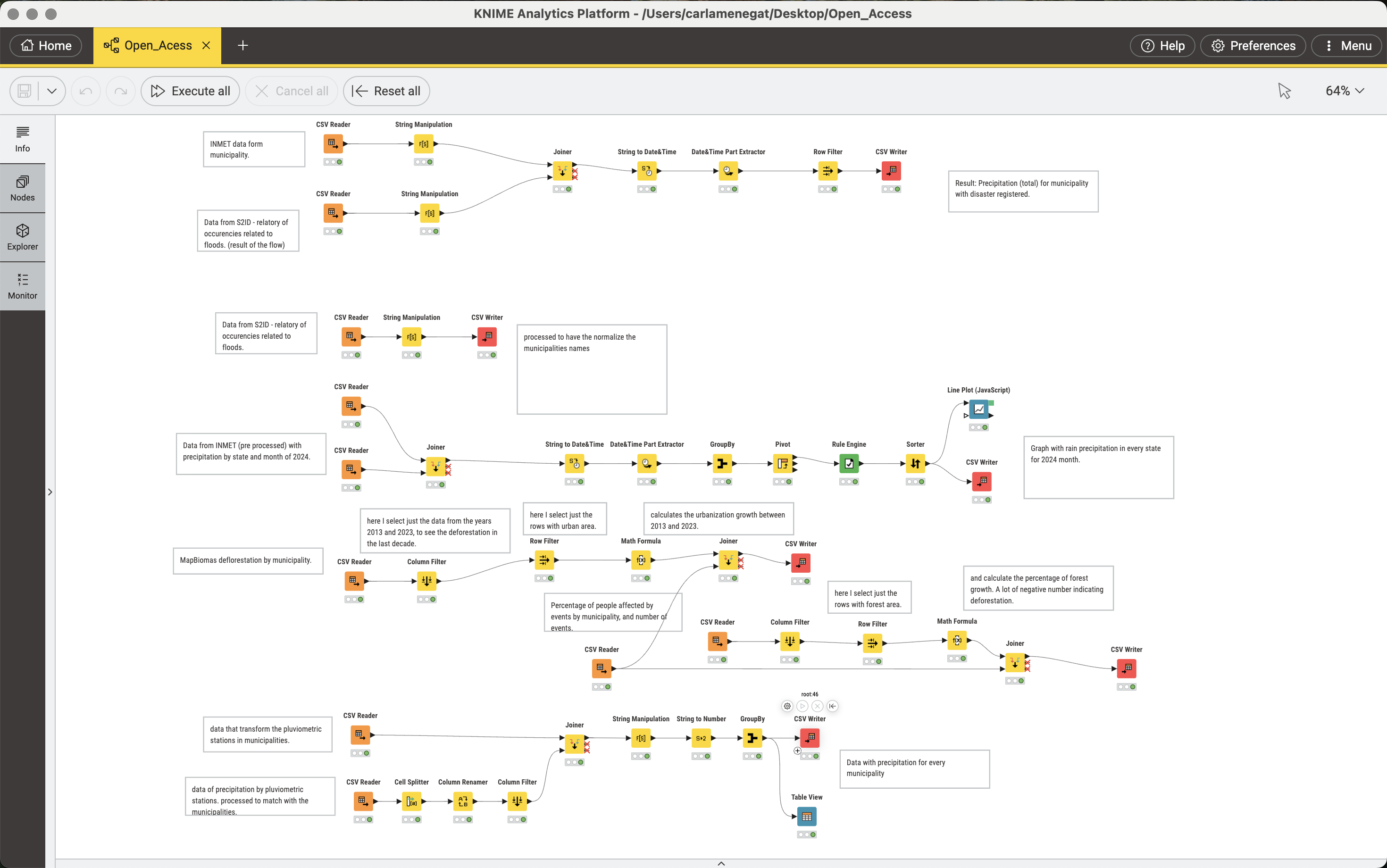
Click on the image to zoom in and see the details of the elaboration process.